|
|
|
|
Archive D-Day Maps from the UK Hydrographic Office. |
|
|
Archive maps for the D-Day Landings now available from Salient Points. Save £4 off RRP!!! |
|
|
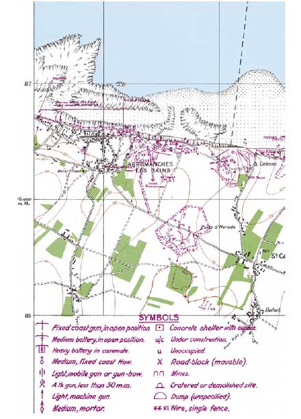
Based at Cowes on the Isle of Wight, two hydrographic surveyors, Lieutenant Commander Berncastle and Lieutenant Glen, were issued with two 32-foot Landing Craft in which to operate. The low profile of these vessels made them difficult to detect by German radar and canoes were used when daring landings on the beaches were required. A
series of Special Charts, including these top secret maps, as well
as charts of our minefields, wreck charts and enemy minefields were drawn
by the cartographers at the Hydrographic Office to ensure that the British
and Allied warships and merchant ships could navigate safely. |
|
|
You can now purchase facsimilie reproduction maps of the D-Day Landing Beaches from Salient Points. RRP £18.99 - Special Price to Salient Points visitors, only £14.99 + P&P - Save Over 20% If you are interested in purchasing a complete set of this unique maps please email me to place your order. I will then contact you regarding payment and postage costs. Email: ryan@salientpoints.com |
|
|
|
|
|
Please feel free to copy the banner below and use it in linking to my website. |
|
|
|
|
 With
the 60th anniversary of D-Day being commemorated this year, the crucial
role of the UKHO (UK Hydrographic Office) prior to the dramatic events of
June 1944 is being remembered with a folio of five replica D-Day landing
maps.
With
the 60th anniversary of D-Day being commemorated this year, the crucial
role of the UKHO (UK Hydrographic Office) prior to the dramatic events of
June 1944 is being remembered with a folio of five replica D-Day landing
maps.